• About
    • Info & Team
    • Support
    • Storefront
  • Work
    • Undergraduate Work
    • Graduate Work
    • Alumni Work
    • Faculty Work
    • Co-op
  • Articles
  • Community
    • Exhibition
    • Event
    • Initiatives
bridge@waterlooarchitecture.com
BridgeBridge
  • About
    • Info & Team
    • Support
    • Storefront
  • Work
    • Undergraduate Work
    • Graduate Work
    • Alumni Work
    • Faculty Work
    • Co-op
  • Articles
  • Community
    • Exhibition
    • Event
    • Initiatives

ARCH692-02 Guest Lectures: ArcGIS and GPS Applications

October 30, 2013 Posted by Kam Tam Community, Event

L2-3 Flyer

03:00 – 04:30 Guest Lecture 1// ESRI CityEngine
[Mark Ho, ESRI Technical Solution Specialist] http://www.esri.com/software/cityengine

Esri® CityEngine® software is a new tool for 3D city modeling in urban planning, rchitecture, simulation, game development, and film production. CityEngine delivers a full uite of industry-leading procedural tools to aggregate geospatial data, lay out and edit street networks, generate and modify buildings, create 3D road profiles and distribute street furniture, control the shape of the skyline, and analyze urban planning projects.

04:30 – 05:30 Guest Lecture 2// Ariadne’s Thread
[Geoff Christou, University of Waterloo MArch 2013] http://geoffchristou.com/index.php?/projects/ariadnes-thread/

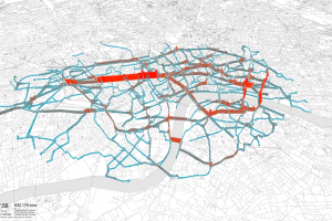
Footprints in the snow and the weathered stone steps of buildings hint at the shape of threads, but the coming of spring and the hardness of stone limit our observations. The Global Positioning System (GPS) now provides us a lens to see the path that individuals, families, and communities take in space-time. When millions of GPS signatures are collected from hundreds of individuals, heritable patterns emerge that embody particular individual’s ideas and practices, as well as those of the society and the environment in which they operate. Besides providing a tool to test assumptions about how space is used, Geoff argues in his thesis that by allowing us to glimpse a terra incognita, mapping worldlines also provides a unique perspective on our spatial relationship to one another.


Kam Tam
+ postsBio
  • Kam Tam
    http://waterlooarchitecture.com/bridge/blog/author/mtam/
    Vote! Vote! Vote!
  • Kam Tam
    http://waterlooarchitecture.com/bridge/blog/author/mtam/
    Ontario Election 2014: June 12th between the hours of 9 AM and 9 PM.
  • Kam Tam
    http://waterlooarchitecture.com/bridge/blog/author/mtam/
    August 2013 Meeting
  • Kam Tam
    http://waterlooarchitecture.com/bridge/blog/author/mtam/
    [WASA][SWAG] OpenForum Spring2013 Announcement/Agenda Consultation
Tags: lectureM1urbanism

About Kam Tam

This author hasn't written their bio yet.
Kam Tam has contributed 8 entries to our website, so far.View entries by Kam Tam

You also might be interested in

LECTURE: Paul Noskiewicz

LECTURE: Paul Noskiewicz

Oct 15, 2013

Paul Noskiewicz of NORR Architects and Engineers will be kicking off[...]

LECTURE: John van Nostrand

LECTURE: John van Nostrand

Jan 23, 2013

Winter 2013 marks the continuation of the Arriscraft Lecture Series[...]

COMPLEX-SYSTEMS MODELING and NEW TOOLS FOR URBAN SPATIAL PLANNING  – Workshops and Lectures

COMPLEX-SYSTEMS MODELING and NEW TOOLS FOR URBAN SPATIAL PLANNING – Workshops and Lectures

Nov 25, 2013

Presented by Waterloo Architecture Integrated Group for Visualization, Design and[...]

Search

BRIDGE

Center for Architecture + Design

7 Melville St. S, Cambridge, ON

  • bridge@waterlooarchitecture.com

© 2025 — BRIDGE.